Multispectral remote sensing refers to the use of sensors to collect data from multiple specific wavelengths of light reflected or emitted by objects on Earth’s surface. This technology has become a game-changer in various fields, from agriculture to environmental management, offering detailed insights into the composition and condition of land, water, and vegetation.
By analyzing data captured across different parts of the electromagnetic spectrum—such as visible light, infrared, and ultraviolet—multispectral remote sensing allows us to see what the naked eye cannot. This capability helps scientists, businesses, and governments make informed decisions about natural resources, urban planning, disaster management, and more.
What is Multispectral Remote Sensing?
Multispectral remote sensing involves capturing images or data from several distinct bands of the electromagnetic spectrum. Unlike traditional photography, which uses just the visible spectrum (red, green, blue), multispectral sensors can detect additional bands, such as near-infrared (NIR) and short-wave infrared (SWIR). These bands reveal unique characteristics of objects, materials, or landscapes based on how they reflect or absorb light.
For example:
- Healthy Vegetation: Reflects more near-infrared light and absorbs visible red light, making it distinguishable from stressed or unhealthy plants.
- Water Bodies: Absorb most infrared light and appear dark, while suspended particles or pollutants alter their reflectance.
- Soil Types: Different minerals and moisture levels produce unique spectral signatures.
How Does Multispectral Remote Sensing Work?
The process begins with a multispectral sensor mounted on a platform like a satellite, drone, or aircraft. Here’s how it works:
- Data Collection
The sensor captures data across multiple spectral bands as it passes over the target area. Each band corresponds to a specific wavelength of light. - Data Processing
Raw data is processed to correct for atmospheric interference, align images from different bands, and calibrate measurements for accurate analysis. - Analysis
The processed data is analyzed to identify patterns, detect changes, and extract valuable information. For example, indices like the Normalized Difference Vegetation Index (NDVI) use the red and NIR bands to assess vegetation health. - Actionable Insights
The insights derived from multispectral data are applied in various fields to make decisions, improve efficiency, and address challenges.
Applications of Multispectral Remote Sensing
Multispectral remote sensing is a versatile tool with applications spanning numerous industries and disciplines. Here are some of its key uses:
- Agriculture and Crop Monitoring
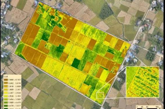
- Farmers use multispectral imagery to monitor crop health, optimize irrigation, and detect pest infestations or diseases.
- NDVI and similar indices help identify stressed plants early, improving yields and reducing resource waste.
- Environmental Management
- Monitoring deforestation, land degradation, and habitat changes are critical applications in conservation.
- Multispectral sensors track changes in vegetation cover, water quality, and soil health, enabling better resource management.
- Disaster Response and Recovery
- After natural disasters like floods, fires, or hurricanes, multispectral remote sensing assesses damage quickly and effectively.
- It helps identify affected areas, track recovery, and support rebuilding efforts.
- Urban Planning and Development
- City planners use multispectral data to analyze land use, monitor urban sprawl, and design green infrastructure.
- Heat island effects in cities can also be studied using infrared bands.
- Water Resources Management
- Multispectral sensors detect changes in water quality, including pollution levels and algal blooms, which are critical for managing freshwater resources.
- Shoreline changes and sedimentation in coastal areas can also be tracked.
- Mineral Exploration
- Different minerals and rock types exhibit unique spectral signatures, making multispectral remote sensing an effective tool for identifying potential mining sites.
- Climate Change Monitoring
- Multispectral data helps scientists track the effects of climate change, such as glacial retreat, desertification, and shifting vegetation patterns.
Benefits of Multispectral Remote Sensing
Why is multispectral remote sensing so widely used? Its advantages include:
- Non-Invasive: Data can be collected from afar without disturbing the environment or the target area.
- Broad Coverage: Satellites can capture images of large areas, while drones provide high-resolution data for smaller, targeted zones.
- Frequent Monitoring: Many satellites, like Sentinel-2 and Landsat, offer regular revisits, enabling continuous monitoring.
- Data Versatility: The same data can be used for multiple purposes, such as analyzing vegetation health, water quality, and soil conditions simultaneously.
Leading Multispectral Remote Sensing Platforms
Several advanced platforms and satellites specialize in multispectral imaging:
- Landsat Series: Managed by NASA and the US Geological Survey, Landsat has been providing multispectral data since 1972, supporting countless research and management projects.
- Sentinel-2: Part of the European Space Agency’s Copernicus program, it offers high-resolution multispectral data for land monitoring.
- MODIS (Moderate Resolution Imaging Spectroradiometer): Provides near-daily coverage for global environmental monitoring.
- PlanetScope: A commercial satellite fleet offering daily multispectral imagery with high spatial resolution.
Challenges in Multispectral Remote Sensing
Despite its numerous benefits, multispectral remote sensing has some challenges:
- Cloud Cover: Optical sensors can’t penetrate clouds, limiting data collection in tropical or rainy regions.
- Cost: High-resolution data from commercial satellites can be expensive, posing a barrier for small-scale users.
- Data Complexity: Analyzing multispectral data requires expertise and specialized software, making it less accessible for some organizations.
The Future of Multispectral Remote Sensing
As technology evolves, multispectral remote sensing is becoming even more powerful. Advances like hyperspectral imaging—which captures hundreds of spectral bands for finer detail—are already expanding its potential applications. Integrating AI and machine learning into analysis workflows is making data interpretation faster and more accurate, enabling real-time decision-making.
Additionally, miniaturized sensors and affordable small satellites are democratizing access to multispectral data, allowing even small organizations to leverage this technology.
Conclusion
Multispectral remote sensing refers to a technology that gives us the ability to see beyond what is visible, offering insights into the health, composition, and changes in our environment. Its applications are vast, from improving agricultural productivity to monitoring climate change impacts. As the technology continues to advance, its potential to address critical challenges and promote sustainable development will only grow, making it an indispensable tool for the modern world.


